10 Rocky Mountain Passes Drivers Swear Off After Close Calls
Transportation engineers and state patrol officers frequently categorize the high-altitude crossings of the Rocky Mountains as some of the most demanding driving environments in North America. These passes feature extreme gradients and unpredictable weather patterns that can shift from clear skies to blinding snow within minutes. Safety experts emphasize that the combination of steep descents and tight hairpins tests the mechanical limits of vehicles, particularly the braking systems of heavy trucks and loaded passenger cars.
State department of transportation officials and veteran mountain guides observe that many motorists underestimate the technical skill required to navigate these routes safely. According to highway maintenance supervisors, the lack of traditional safety features like guardrails in certain sections is a deliberate choice due to heavy snow removal requirements, but it leaves no room for error. Understanding the specific hazards of each pass allows professional drivers and prepared travelers to make informed decisions about when to seek an alternate route or wait for better conditions.
Red Mountain Pass In Colorado
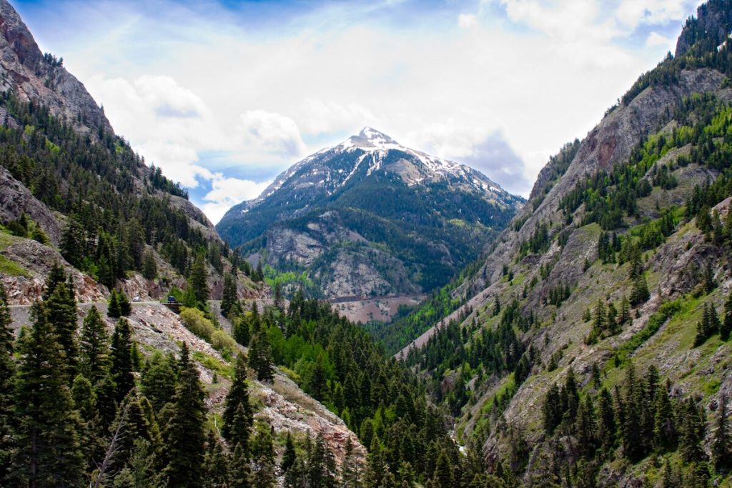
Highway safety engineers often refer to this stretch of US Highway 550 as the most intimidating mountain road in the United States. Part of the legendary Million Dollar Highway, the pass reaches an elevation of 11018 feet and is famous for its lack of guardrails along sheer cliffs. State patrol officers note that the narrow lanes and steep drop-offs provide zero margin for error during heavy rain or winter storms. The road is carved directly into the side of the San Juan Mountains, where rockslides and avalanches are constant natural threats that require frequent seasonal closures.
Professional mountain drivers emphasize that the descent into the town of Ouray is particularly grueling for braking systems. Maintenance crews explain that the absence of guardrails is necessary to allow snowplows to push heavy accumulations over the edge, but this creates a psychological challenge for many motorists. Drivers who have experienced the vertigo-inducing views and tight turns often choose to take the much longer western detour through Lizard Head Pass to avoid the stress of this high-alpine crossing.
Wolf Creek Pass In Colorado
State department of transportation officials identify this crossing on US Highway 160 as a notorious site for commercial vehicle accidents. The west side of the pass features a continuous seven percent downgrade that spans over eight miles, which frequently leads to overheated brakes and loss of vehicle control. Wildlife biologists also monitor this area closely because the high-density forest and migration corridors result in frequent large animal crossings that can surprise even the most attentive drivers.
Safety experts at the Colorado State Patrol highlight the dangerous hairpin turn located near the base of the descent as a primary site for rollovers. While the road has been widened in many sections, the sheer length of the grade can deceive drivers into maintaining too much speed before they reach the most technical curves. Two runaway truck ramps are positioned along the route, serving as a stark reminder of the mechanical failures that occur when drivers fail to use lower gears to manage their momentum.
Beartooth Pass On The Montana Border
Park rangers and highway maintenance staff in the Custer Gallatin National Forest manage this high-altitude route which is often described as the most beautiful yet terrifying drive in the region. Reaching nearly 11000 feet, the pass is subject to extreme winds and sudden snowfalls even during the peak of summer. The road features a series of dramatic switchbacks that climb more than 5000 vertical feet, offering little protection for those who are uncomfortable with heights or narrow roadway shoulders.
National Park Service officials explain that the road is only open from late May through mid-October because the clearing of snow is such a massive undertaking. The high-alpine environment means that drivers must be prepared for freezing temperatures and limited visibility at any time. Many travelers who attempt the route for the scenery find the combination of sheer drops and lack of physical barriers so overwhelming that they swear off the return trip, opting for less vertical alternatives through the park system.
Independence Pass In Colorado
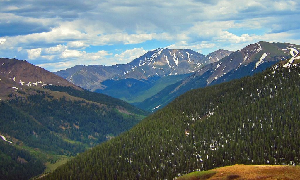
State highway officials classify State Highway 82 as the highest paved state road in the region, crossing the Continental Divide at 12095 feet. This pass is strictly restricted to vehicles under 35 feet in length due to the presence of extremely narrow sections where the road becomes effectively a single lane. Transportation planners note that the tight turns and overhanging rock walls make it impossible for larger recreational vehicles or commercial trucks to pass one another safely.
The pass is closed for more than half the year because of massive avalanche risks and the impracticality of plowing such steep and narrow switchbacks. Even during the summer months, drivers often encounter situations where they must yield to oncoming traffic on sections of road that lack a center line. The combination of extreme altitude and the proximity of the tires to the edge of the asphalt leads many visitors to vow never to repeat the crossing once they reach the safety of Aspen or Twin Lakes.
Teton Pass In Wyoming
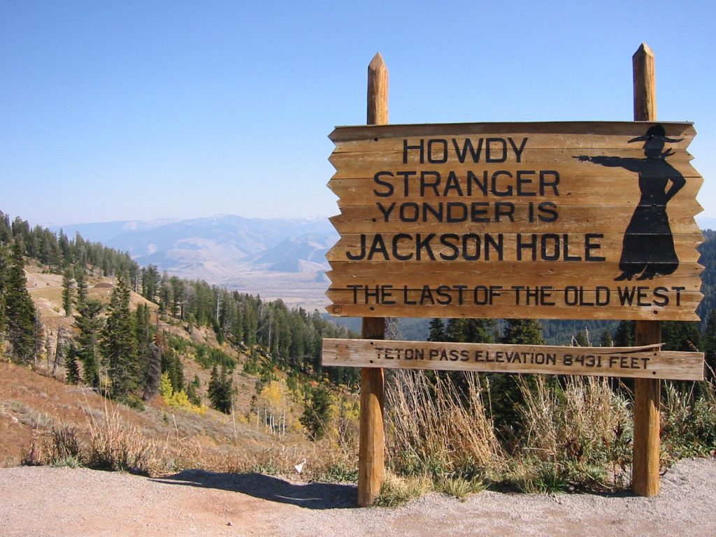
Wyoming Department of Transportation officials frequently issue warnings about the ten percent grades that define this critical link between Jackson Hole and Victor. The steepness of the terrain makes it one of the most unforgiving environments for truck drivers and anyone towing a trailer. In fact, state authorities implement a seasonal ban on all trailers during the winter months to prevent jackknife accidents and road blockages that occur during heavy snow cycles.
Safety analysts point out that the pass has a high frequency of brake-related incidents due to the sustained intensity of the descent. The road is also a primary path for local commuters, which creates a high-pressure driving environment where locals and tourists must share narrow, icy lanes. The combination of professional-grade steepness and heavy traffic volume creates a stressful experience that leads many casual drivers to seek the longer route through the Snake River Canyon.
Monarch Pass In Colorado
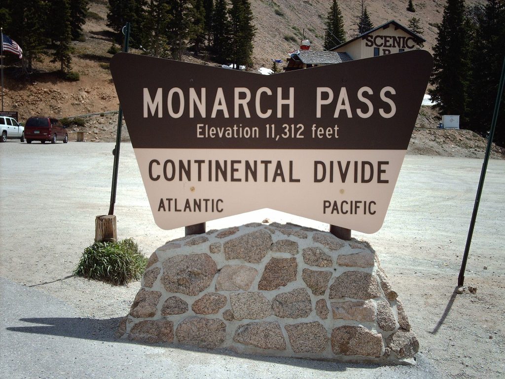
Winter driving experts and local meteorologists often cite this crossing on US Highway 50 as one of the most feared roads in the country during the snowy season. Reaching an elevation of 11312 feet, the pass is a major conduit for east-west travel that stays open year-round despite receiving massive amounts of snowfall. Highway maintenance crews work around the clock to mitigate the effects of blowing snow and black ice, which can make the steep curves virtually invisible.
State patrol records show that the combination of high speeds and sudden weather shifts results in frequent multi-vehicle accidents. The pass features several sweeping turns that can become treacherous when ice forms in the shadows of the surrounding peaks. Many drivers who have been caught in a whiteout at the summit describe the experience as life-altering, leading them to avoid the route entirely when winter storms are forecasted in the central mountains.
Loveland Pass In Colorado
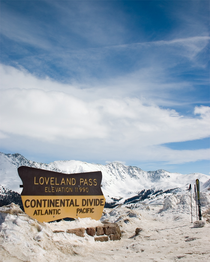
Hazardous materials investigators and commercial trucking experts are intimately familiar with this route because it serves as the mandatory bypass for tankers that are prohibited from the Eisenhower Tunnel. The pass reaches an elevation of 11990 feet and consists of a classic shelf road with tight switchbacks and significant vertical exposure. Because it carries a high volume of fuel trucks, the risk of fiery accidents and environmental contamination is a constant concern for state officials.
Transportation safety officers note that the pass is often used by backcountry skiers who park along the tight shoulders and hitchhike back to the summit, adding another layer of complexity to the driving environment. The road is frequently closed for avalanche mitigation, as the steep slopes above the highway are prone to natural slides. Navigating the pass during a storm while sharing the road with heavy tankers and pedestrians is an ordeal that many drivers refuse to experience a second time.
Berthoud Pass In Colorado
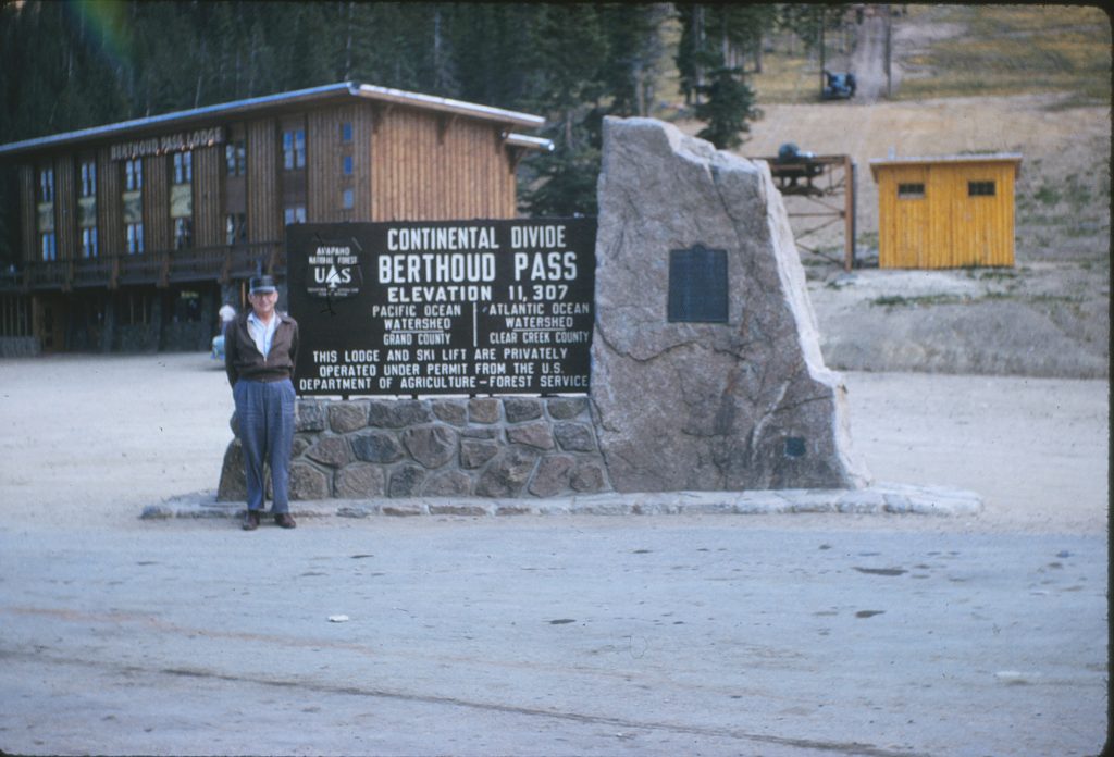
Avalanche forecasters and search and rescue teams monitor this section of US Highway 40 with high vigilance due to its history of natural slides. The pass features a series of intense switchbacks that climb toward the Continental Divide at 11307 feet. In recent years, several large avalanches have reached the roadway, occasionally trapping vehicles and requiring extensive rescue operations. These events highlight the raw power of the mountain environment and the vulnerability of the infrastructure.
Maintenance supervisors at the department of transportation explain that the geography of the pass makes it a natural funnel for heavy snow and high winds. The road serves as the primary access point for popular ski areas, resulting in high-density traffic on weekends when road conditions are at their worst. Drivers who have witnessed the speed with which a slide can cover the road often find the route too stressful to justify, especially when the threat of additional slides remains high.
Slumgullion Pass In Colorado
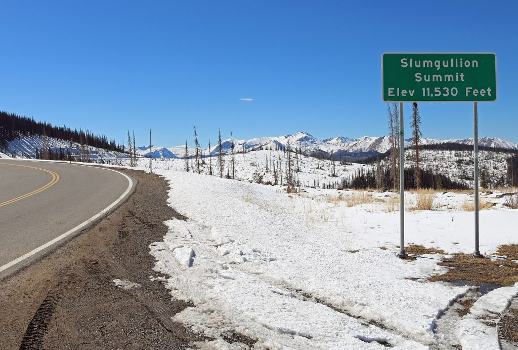
Civil engineers and geological experts recognize this crossing on State Highway 149 as having the steepest grade of any continuously paved road in the state. The north side of the pass features a nine percent incline that begins almost immediately outside the town of Lake City. The pass is named after the nearby Slumgullion Earthflow, a massive moving landslide that serves as a reminder of the unstable geological nature of the surrounding peaks.
The relentless nature of the climb and descent means that vehicles have almost no opportunity to cool their engines or brakes. While the pass is well-maintained and remains open throughout the winter, the sheer steepness can be overwhelming for those not used to high-alpine driving. Experts suggest that the technical demand of maintaining traction on such a sharp incline leads many recreational travelers to choose a flatter route through the San Luis Valley instead.
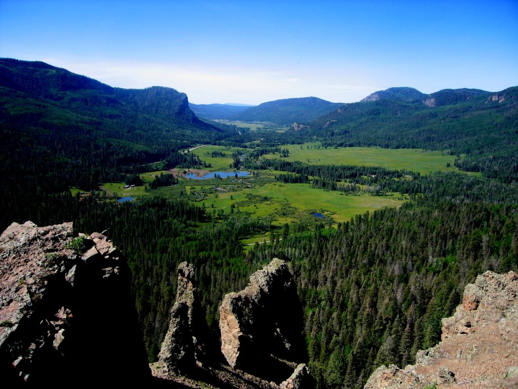
Lizard Head Pass In Colorado
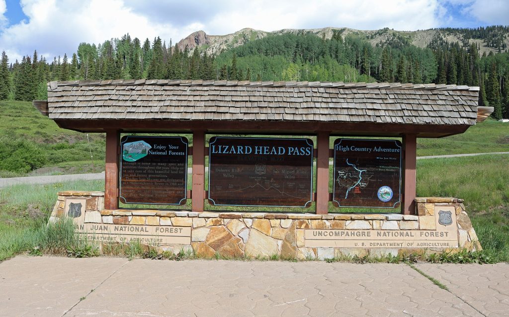
Wildlife biologists and forest rangers often describe this pass as a crucial corridor for lynx and elk, but drivers know it for its rugged terrain and frequent winter closures. Located on State Highway 145, the pass provides stunning views of the San Miguel Mountains while presenting significant challenges during the transition seasons. The northern half of the pass near Telluride features a series of tight switchbacks that can become extremely slick when the high-altitude sun melts the top layer of snow during the day.
State patrol officers emphasize that the road is often used as the primary detour when Red Mountain Pass is closed, which can lead to overcrowding on a route that is already technically demanding. The isolation of the area means that emergency response times can be longer than in more central regions of the state. Many motorists who have navigated the icy curves during a spring storm find the remoteness and the steep grades a reason to avoid the area during the winter months.