11 Old Railroads That Quietly Became Women’s Favorite U.S. Trails
Civil engineers and urban planners report that the decommissioning of historic freight lines has sparked a revolution in outdoor recreation through the rails-to-trails movement. These corridors, originally designed for heavy locomotives, provide unique structural advantages for modern pedestrians and cyclists. Experts at the Rails-to-Trails Conservancy emphasize that the gentle grades and wide berths of these converted paths create a highly accessible environment that caters to a broad demographic of female travelers seeking safe and scenic transit through diverse American landscapes.
Landscape architects and environmental psychologists note that these trails function as linear parks that bridge the gap between urban centers and deep wilderness. According to community safety consultants, the high visibility and level surfaces of rail-trails reduce the physical and psychological barriers to solo exploration. By repurposing the iron paths of the industrial age into emerald ribbons of greenery, these eleven historic routes have evolved from conduits of commerce into premier destinations for wellness, history, and community connection.
The Virginia Creeper Trail In Virginia

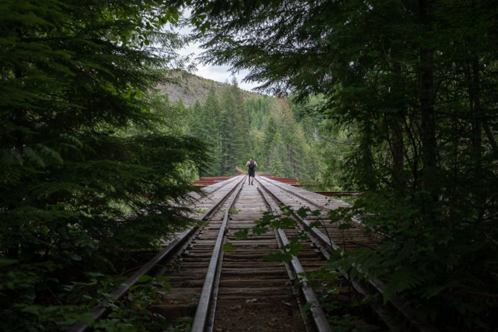
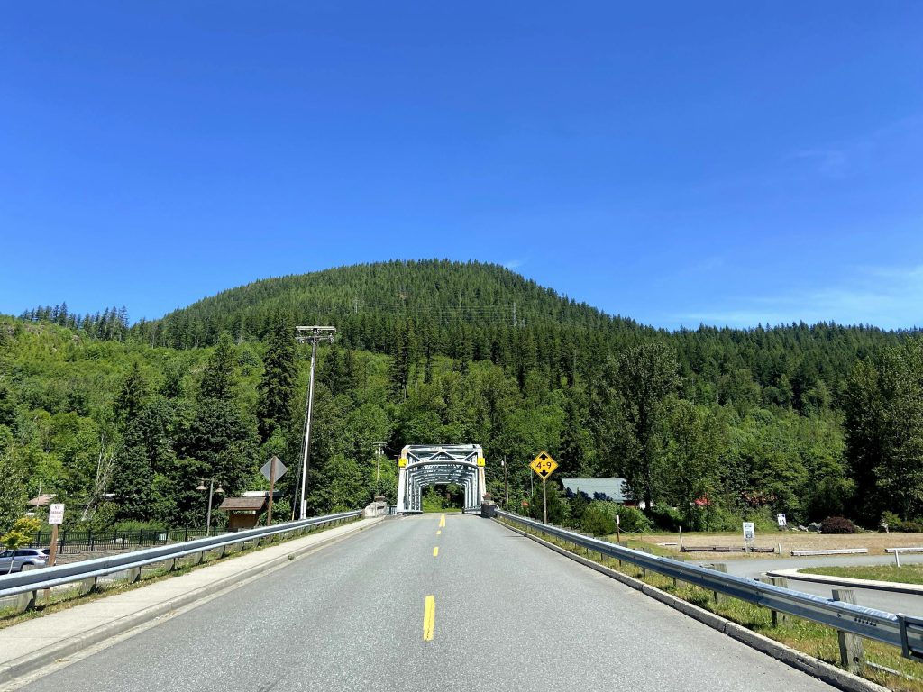
Regional historians and recreation specialists identify the Virginia Creeper Trail as a masterpiece of transition from the Norfolk and Western Railway into a premier scenic corridor. The path descends nearly three thousand feet from the high country of Whitetop Mountain to the town of Abingdon, crossing dozens of historic wooden trestles along the way. Civil engineers explain that the original railroad engineering necessitated a gradual decline, which now allows cyclists and hikers to glide through the Jefferson National Forest with minimal exertion.
Tourism directors and local hospitality experts observe that the trail has become a vital economic engine for the surrounding Appalachian communities. Women often select this route because of the reliable shuttle services and the charming trail-adjacent cafes that offer a sense of security and support. The lush forest canopy and the sound of Laurel Creek accompanying the path provide a sensory experience that experts say is instrumental in reducing stress and fostering a deep connection with the rural South.
The Katy Trail In Missouri
State park rangers and agricultural historians describe the Katy Trail as the longest continuous rail-trail in the United States, following the historic path of the Missouri-Kansas-Texas Railroad. Much of the route hugs the towering limestone bluffs of the Missouri River, offering a flat and well-maintained crushed stone surface. Experts note that the trail serves as a cultural corridor, passing through historic river towns and the rolling vineyards of the Missouri Rhineland, where the nineteenth-century architecture remains remarkably preserved.
Community planners and safety auditors highlight the frequent trailheads and the presence of bike-friendly bed and breakfasts as key features that appeal to female adventurers. The open visibility across the river valley and the gentle terrain make it an ideal choice for multi-day expeditions or long-distance cycling. Because the path follows the river, the grade is almost imperceptible, allowing travelers to focus on the biological diversity of the riparian corridor and the heritage of the Lewis and Clark expedition.
The High Line In New York
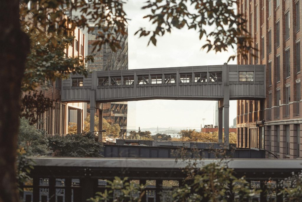
Urban designers and sociologists recognize the High Line as a global icon of adaptive reuse that transformed an elevated West Side freight line into a botanical sanctuary. The park sits thirty feet above the city streets, providing a unique vantage point of the Manhattan skyline and the Hudson River. Landscape architects explain that the plant palettes were inspired by the wild vegetation that grew on the tracks during their decades of abandonment, creating a rugged but refined urban garden.
Security consultants and city officials point to the High Line as a success story in public safety through design, where high foot traffic and constant oversight create a secure environment for solo walkers. The presence of art installations and seasonal programming ensures that the space remains vibrant and engaging throughout the year. For many women, the High Line offers a necessary psychological reprieve from the steel and glass of the city, proving that industrial relics can become essential lungs for the modern metropolis.
The Bizz Johnson National Recreation Trail In California
Forest Service rangers and geological experts highlight the Bizz Johnson Trail as a rugged journey through the Susan River Canyon in Northern California. The trail follows the former Fernley and Lassen Branch of the Southern Pacific Railroad, passing through two historic tunnels and crossing the river twelve times on massive bridges. Experts explain that the route offers a dramatic transition from the high desert of the Great Basin to the dense pine forests of the Sierra Nevada.
Wilderness guides and outdoor safety specialists note that the trail is particularly popular during the autumn when the canyon’s riparian trees turn brilliant shades of gold. The wide, level path allows for a deep wilderness experience without the technical difficulties often associated with mountain hiking. Women frequently choose this trail for its profound quietude and the sense of history that lingers in the abandoned railroad infrastructure, providing a safe but adventurous escape from urban life.
The Cape Cod Rail Trail In Massachusetts
Coastal geographers and regional planners identify the Cape Cod Rail Trail as a vital artery that connects the salt marshes, pine barrens, and historic villages of the Lower Cape. Built on the right-of-way of the former Old Colony Railroad, the path offers twenty-five miles of paved, level surface that avoids the heavy traffic of the main Cape roads. Experts observe that the trail provides direct access to several national seashore beaches and kettle ponds, making it a favorite for those seeking a mix of exercise and ocean scenery.
Local hospitality consultants emphasize that the trail is integrated into the social fabric of the Cape, with numerous bike shops and bakeries situated directly on the path. The high visibility and the family-friendly atmosphere of the region contribute to a strong sense of community security. For travelers looking to explore the historic charm of New England, the rail trail offers a car-free way to visit the windmills, lighthouses, and cedar-shingled homes that define the Massachusetts coast.
The Route Of The Hiawatha In Idaho
Mountain safety experts and railway historians describe the Route of the Hiawatha as the crown jewel of the rails-to-trails movement in the Pacific Northwest. Stretching across the Bitterroot Mountains near the Montana border, the trail features ten tunnels and seven sky-high trestles. National forest rangers explain that the centerpiece of the ride is the St. Paul Pass Tunnel, which is nearly two miles long and requires powerful lights to navigate the absolute darkness of the mountain interior.
Travel planners and logistics coordinators note that the trail is managed as a seasonal recreation site, complete with bike rentals and return shuttles. This structured support system makes the dramatic mountain terrain accessible to those who might otherwise be intimidated by the remote wilderness. The breathtaking views of the rugged forest from the high steel bridges provide a sense of scale that experts say is both humbling and empowering for female travelers.
The Silver Comet Trail In Georgia
Urban planners and recreational directors recognize the Silver Comet Trail as a premier example of how rail-trails can connect suburban communities with rural landscapes. Running from the outskirts of Atlanta toward the Alabama border, the trail follows the path of the former Silver Comet passenger train. Civil engineers emphasize that the paved surface and the bridge crossings over deep ravines were designed to accommodate high-speed rail, resulting in a smooth and efficient path for modern cyclists and runners.
Safety auditors and local law enforcement have prioritized the monitoring of the trail, ensuring that the heavy usage by locals creates a self-policing and secure environment. The transition from the developed trailhead hubs into the quiet, wooded sections of Paulding and Polk counties offers a diverse sensory journey. Women frequently praise the trail for its well-marked miles and the ease with which one can customize the distance of their outing, making it a staple of the Georgia outdoor scene.
The Banks-Vernonia State Trail In Oregon
Forestry experts and park naturalists identify the Banks-Vernonia State Trail as a tranquil path through the heart of the Oregon Coast Range. This twenty-one-mile paved trail follows the former Spokane, Portland and Seattle Railway, crossing thirteen historic bridges and a massive timber trestle. Experts explain that the trail winds through second-growth forests of Douglas fir and maple, providing a lush, green canopy that shields travelers from the sun and light rain.
Wilderness therapists note that the acoustic tranquility of the forest sections makes this trail a top choice for those seeking mental restoration. The gentle climb toward the summit of the Coast Range is barely noticeable due to the railroad engineering, making it accessible for hikers and cyclists of all skill levels. The presence of the L.L. Stub Stewart State Park along the route provides a secure camping and staging area, fostering a safe environment for multi-day explorations of the Pacific Northwest wilderness.
The Great Allegheny Passage In Pennsylvania
National heritage specialists and economic development experts celebrate the Great Allegheny Passage as a world-class trail that links Pittsburgh to Cumberland, Maryland. The path traverses the rugged Allegheny Mountains, utilizing a series of tunnels and bridges to maintain a steady, low-grade ascent. Experts note that the trail follows the historic corridors of the Western Maryland Railway and the Pittsburgh and Lake Erie Railroad, offering a deep dive into the industrial heart of the Appalachians.
Hospitality consultants highlight the trail-town model, where small communities have transformed themselves into welcoming hubs for travelers. The abundance of trailside lodging and dining options creates a structured and safe environment for solo female travelers or groups. The spectacular views of the Youghiogheny River and the engineering marvel of the Big Savage Tunnel provide a memorable journey through a landscape that was once the backbone of American manufacturing.
The Longleaf Trace In Mississippi
Regional planners and agricultural experts describe the Longleaf Trace as a scenic journey through the piney woods and small towns of South Mississippi. Built on the former Mississippi Central Railroad, the trail offers a twenty-four-mile paved path that connects Hattiesburg to Prentiss. Forestry experts emphasize that the trail provides a unique look at the longleaf pine ecosystem, which was once the dominant landscape of the American Southeast and is now a focus of intense conservation efforts.
Community safety coordinators note that the trail is a point of local pride, featuring well-maintained rest stops and equestrian paths that run parallel to the main trail. The flat terrain and the shaded corridors make it a comfortable choice even in the humid Southern summers. Women frequently choose this route for the quiet hospitality of the trail towns and the opportunity to experience the rural beauty of Mississippi away from the high-speed corridors of the interstate.
The Swamp Rabbit Trail In South Carolina
Urban development experts and health advocates identify the Swamp Rabbit Trail as a catalyst for the revitalization of the Greenville region. The trail follows the former Carolina, Knoxville and Western Railway, winding alongside the Reedy River and through the campus of Furman University. Experts explain that the trail has successfully integrated the urban center of Greenville with its northern suburbs and the foothills of the Blue Ridge Mountains, creating a seamless recreation corridor.
Safety analysts and park directors highlight the high visibility and the vibrant social energy of the trail, which is constantly used by commuters and fitness enthusiasts. The presence of the Swamp Rabbit Cafe and Grocery as a central hub provides a safe and welcoming destination for travelers. The blend of urban parks, university grounds, and quiet riverside forests offers a diverse and engaging environment that has become a defining feature of the modern South Carolina outdoors.