10 U.S. Cliffs Women Visit Once—and Never Forget
Geologists and park rangers observe that certain vertical landscapes across the United States possess a unique gravitational pull on the female traveler. These high-altitude destinations offer more than just a scenic photograph; they provide a profound sense of scale and perspective that shifts one’s internal compass. Experts at the National Park Service note that the psychological impact of standing at a sheer drop, where the earth abruptly ends and the horizon begins, creates a lasting sensory memory. Whether it is the salt spray of the Atlantic or the dry heat of a desert canyon, these cliffs represent the raw, unedited power of the natural world.
Travel psychologists and veteran outdoor guides explain that visiting these specific precipices often marks a significant personal milestone. Many women seek out these locations during transformative periods, using the physical challenge of the ascent and the stillness of the summit as a form of natural therapy. The quietude found at the edge of a thousand-foot drop allows for a level of reflection that is difficult to achieve in urban environments. This emotional resonance is why these landmarks are rarely visited as a casual checkbox but rather as a singular, unforgettable experience.
From the rugged coastlines of Maine to the ancient granite of the Sierra Nevada, the American landscape is defined by its dramatic elevation changes. Safety officials emphasize that respect for the terrain is paramount, as the beauty of these cliffs is matched only by their inherent risk. Understanding the geological history and the environmental delicate balance of these sites enhances the visitor’s appreciation. The following ten locations represent the most iconic and emotionally stirring cliffs in the country, curated through the lens of expert recommendations and traveler testimonies.
Mather Point At The Grand Canyon
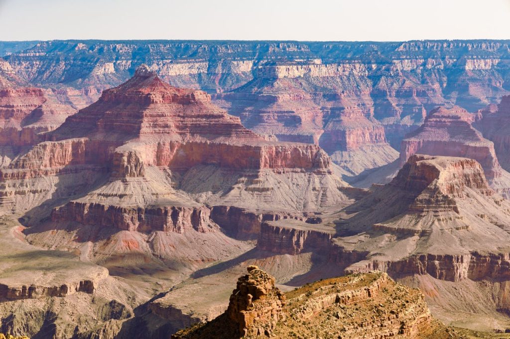
Park rangers and geologists frequently cite Mather Point as the definitive introduction to the verticality of the American Southwest. Situated on the South Rim of the Grand Canyon, this limestone promontory provides a panoramic view that encompasses millions of years of sedimentary history. The sheer drop into the canyon floor reveals the relentless power of the Colorado River, which has carved through the rock to a depth of over one mile. Experts explain that the specific lighting at sunrise transforms the canyon walls into a kaleidoscope of deep ochre and vibrant gold, a visual phenomenon that remains etched in the memory of every visitor.
Conservationists and naturalists point out that the accessibility of Mather Point does not diminish its profound impact. While many overlooks offer glimpses of the canyon, the structural jut of this particular cliff allows for a nearly two-hundred-seventy-degree view of the vast chasm. Wildlife biologists often observe California condors soaring on thermals just below the rim, providing a rare look at one of the largest birds in North America. For many women, the first sight of the horizon stretching into infinity from this ledge serves as a humbling reminder of the earth’s ancient timeline.
Safety experts at Grand Canyon National Park stress the importance of staying behind the designated railings, as the limestone edges can be unstable due to erosion. They recommend visiting during the shoulder seasons of spring or autumn to avoid the intense summer heat that can make the high-altitude air feel suffocating. The physical sensation of the wind rushing up from the canyon floor creates a tactile connection to the landscape that photographs simply cannot capture. It is a place where the silence of the desert feels heavy and significant, leaving a permanent mark on the traveler’s psyche.
El Capitan In Yosemite Valley
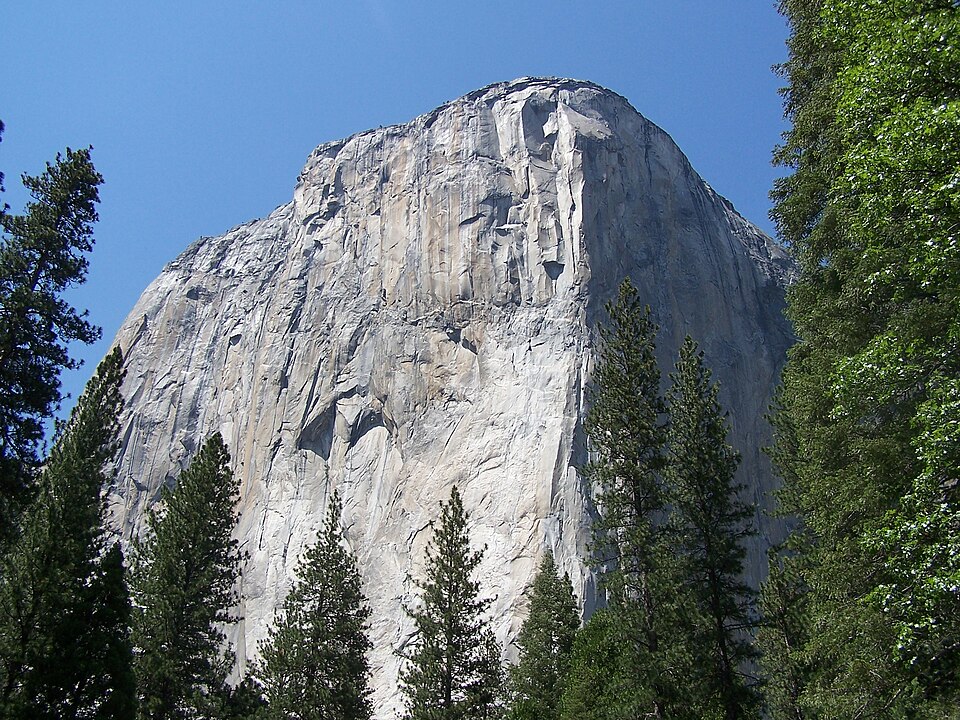
Rock climbing legends and Yosemite park rangers describe El Capitan as the world’s most impressive granite monolith. Rising three thousand feet from the floor of Yosemite Valley, this sheer vertical face is a testament to the cooling of ancient magma and the subsequent scouring by glacial ice. Geologists emphasize that the lack of cracks on its face makes it a masterpiece of structural integrity, appearing as a singular, unbroken wall of stone. For female travelers, standing at the base or viewing the cliff from across the meadow offers a sense of awe that is both intimidating and deeply inspiring.
Professional photographers and light specialists note that El Capitan is particularly famous for the Horsetail Fall event, often referred to as the firefall. During a brief window in February, the setting sun hits the waterfall at an angle that makes the water appear like flowing lava. This rare alignment of celestial mechanics and geology draws spectators from across the globe, creating a shared moment of wonder. Even on ordinary days, the way the shadows of the clouds dance across the granite surface provides a dynamic display of light and dark that changes by the minute.
Wilderness guides explain that while most people view El Capitan from the valley floor, the hike to the summit offers an entirely different perspective on the vertical world. Looking down from the edge of the granite crown provides a dizzying view of the Merced River winding through the pines like a silver thread. This vantage point requires a rigorous physical effort, making the eventual arrival at the cliff’s edge feel like a hard-won victory. The memory of that sheer drop and the vastness of the Sierra Nevada mountains beyond is something that stays with a person for a lifetime.
The Kalaupapa Cliffs Of Molokai
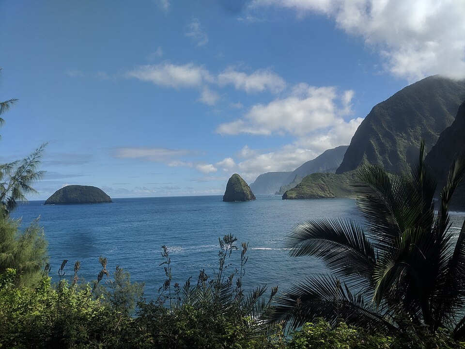
Marine biologists and Hawaiian historians recognize the Kalaupapa Cliffs on Molokai as the highest sea cliffs in the world. These emerald-green walls rise nearly two thousand feet directly out of the Pacific Ocean, creating a dramatic barrier between the land and the sea. Experts explain that these cliffs were formed by a massive landslide millions of years ago, which sent a significant portion of the island into the depths of the ocean. The resulting vertical landscape is so steep that it remains inaccessible by traditional roads, requiring a mule ride or a strenuous hike to reach the settlement at the base.
Cultural experts and storytellers emphasize that the beauty of these cliffs is inextricably linked to the poignant history of the Kalaupapa peninsula. For decades, the area served as a place of isolation for individuals with Hansen’s disease, and the towering cliffs acted as a natural prison wall. Today, the site is a National Historical Park where the spirit of resilience is palpable. Visitors who look up at the towering green precipices from the shore or down from the overlooks above often speak of a deep sense of peace and somber reflection that is unique to this remote Hawaiian island.
Conservationists highlight the unique biodiversity found on these vertical slopes, where rare native plants cling to the rock faces far out of reach of invasive species. The constant moisture from the trade winds keeps the cliffs a vibrant, saturated green that contrasts sharply with the deep blue of the surrounding ocean. Standing at the edge of the overlook, one feels the true isolation of Molokai, as the sound of the crashing waves below is the only thing that breaks the silence. It is an experience of raw nature and human history that is impossible to forget.
The Cliffs Of Moher In Ireland
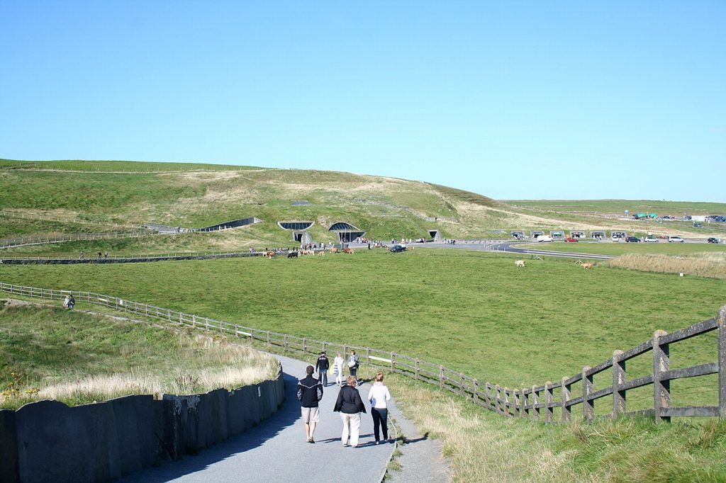
While located outside the United States, the Cliffs of Moher are frequently cited by American travel consultants as the most sought-after international cliff experience for domestic travelers. However, within the U.S. borders, the sheer coastal bluffs of Acadia National Park in Maine offer a similar, albeit more rugged, experience. State park officials and coastal geologists point to the dramatic granite edges of Otter Cliff as a premier destination for those seeking a confrontation with the Atlantic. These cliffs rise one hundred and ten feet above the water, offering a direct view of the powerful swells that have shaped the Maine coastline over millennia.
Marine ecologists note that the intertidal zones at the base of these cliffs are some of the most diverse in the country. The constant movement of the tide creates a harsh but nutrient-rich environment for a variety of sea life, which can often be observed from the heights above. During the winter months, the spray from the waves freezes onto the granite, creating a treacherous but beautiful coating of black ice. Experts advise that the best way to experience these cliffs is through the Ocean Path, which provides multiple vantage points of the jagged rock formations and the distant lighthouses.
Professional landscape designers often study the natural weathering of these granite faces to understand how stone reacts to salt and wind over centuries. The texture of the rock is coarse and unyielding, providing a sturdy platform for those who wish to watch the sunrise over the easternmost edge of the country. For many women, the experience of the cold Atlantic wind and the rhythmic thumping of the waves against the stone provides a grounding sensation that is both invigorating and meditative. The memory of that salt-crusted air and the gray-blue horizon is a permanent souvenir of the Maine coast.
Horseshoe Bend In Arizona
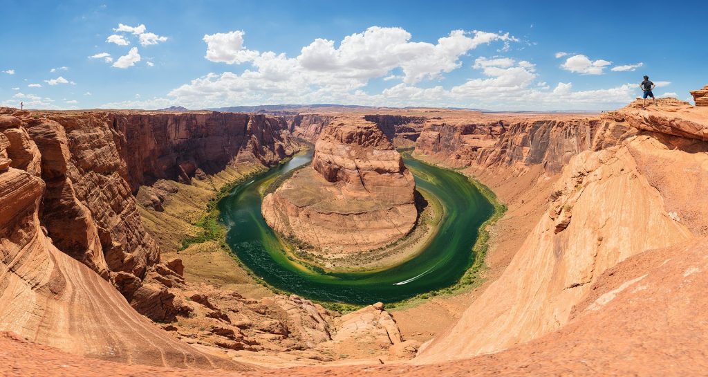
Hydrologists and desert geologists describe Horseshoe Bend as one of the most symmetrical and aesthetically pleasing examples of river erosion in the world. Located near Page, Arizona, this social-media-famous landmark features a thousand-foot drop to the Colorado River as it makes a dramatic two-hundred-seventy-degree turn. Experts explain that the river has cut through layers of Navajo sandstone, revealing the characteristic red and orange hues that define the American Southwest. The sheer scale of the bend is often underestimated until one stands at the rim and notices the tiny specks of rafts floating on the emerald water far below.
Tourism officials and local guides have seen a massive increase in visitors over the last decade, leading to the installation of improved safety viewing platforms. Despite the crowds, the psychological impact of the drop remains potent, as the absence of a visible floor directly beneath the rim creates a sensation of floating over the canyon. Photographers suggest that the best time to visit is during the late afternoon when the shadows begin to stretch across the river, highlighting the intricate textures of the sandstone walls. The contrast between the fiery rock and the cool green water is a visual anchor that many travelers carry with them long after the trip.
Geology professors point out that the cross-bedding visible in the cliff walls tells the story of ancient sand dunes that existed during the Jurassic period. Each layer represents a different era of wind and water movement, making the cliff a vertical textbook of Earth’s history. For the traveler, this realization adds a layer of depth to the visual spectacle, turning a simple overlook into a journey through time. The stillness of the desert air and the massive scale of the river’s curve create a sense of profound quiet that stays with the visitor.
The Painted Canyon In North Dakota
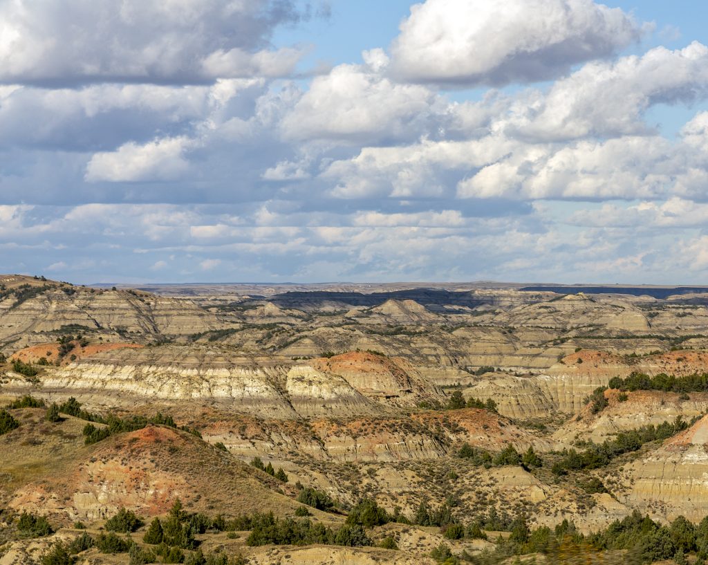
Wilderness historians and park rangers in Theodore Roosevelt National Park often refer to the Painted Canyon as the most colorful vertical landscape in the Great Plains. These cliffs and buttes are composed of layers of silt, clay, and coal, which have been weathered into a maze of intricate shapes and vibrant stripes. Geologists explain that the red layers, known as scoria, were formed when ancient coal seams caught fire and baked the surrounding clay into a natural brick. This process has created a landscape that looks more like a modern art gallery than a typical prairie environment.
Wildlife biologists note that the cliffs provide essential habitat for bighorn sheep and golden eagles, both of which can frequently be seen from the overlook at the Painted Canyon Visitor Center. The transition from the flat, grassy plateau to the sudden, jagged drop into the badlands is a jarring and memorable geographic shift. Experts emphasize that the best way to appreciate the depth of the canyon is to take the trail that descends from the rim, allowing for a close-up view of the fragile, crumbly textures of the cliff walls. This intimate contact with the earth reveals the delicate nature of a landscape that is constantly being reshaped by wind and rain.
Travel writers often highlight the Painted Canyon as a place of solitude, as it is far less crowded than the more famous canyons of Arizona and Utah. The vastness of the North Dakota sky combined with the multi-colored cliffs creates a sense of infinite space that is both overwhelming and liberating. For women traveling through the American West, this stop often serves as an unexpected highlight, offering a palette of colors that seems almost impossible in such a remote region. The memory of the sun setting over the striped buttes is a vivid reminder of the diverse beauty of the American interior.
Black Canyon Of The Gunnison
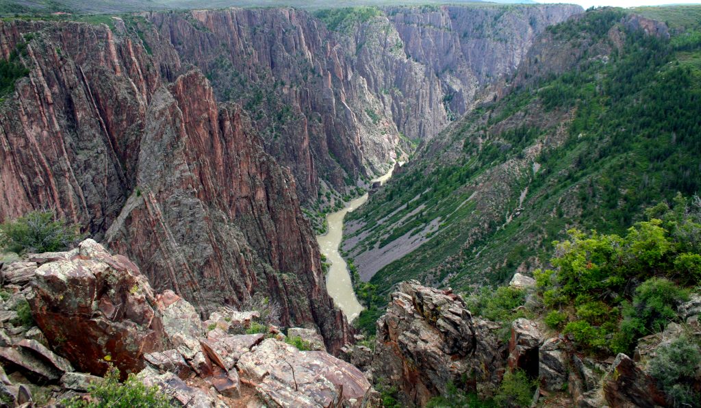
Geologists and river guides describe the Black Canyon of the Gunnison as one of the most intimidating and dramatic vertical landscapes in North America. Located in western Colorado, this canyon is characterized by its exceptionally steep walls and the dark, Precambrian rock that gives the canyon its name. Experts explain that the walls are so narrow and deep that sunlight rarely reaches the bottom, keeping the shadows long and the atmosphere moody. At its deepest, the canyon drops two thousand seven hundred feet, with the Gunnison River appearing as a violent, white-water thread at the base.
Engineering experts who have studied the canyon marvel at the “Painted Wall,” a cliff face that features intricate light-colored pegmatite dikes snaking through the dark schist. This visual pattern is a result of molten rock being forced into cracks in the older stone billions of years ago, creating a natural mural on a massive scale. For the traveler, the experience of looking over the edge into the abyss is often described as heart-stopping, as the sheer verticality is more extreme than even the Grand Canyon. The vertical walls are so steep that they create their own microclimates, with different plants and animals inhabiting various levels of the cliff.
Park safety officers warn that the trails leading into the canyon are some of the most strenuous in the National Park system, requiring a high level of physical fitness and preparation. Most visitors opt for the scenic rim drives, which offer multiple overlooks with varying perspectives on the dark, jagged walls. The sensation of looking into a chasm that is both incredibly narrow and impossibly deep creates a unique form of vertigo that is difficult to replicate elsewhere. It is a place that feels ancient and unyielding, leaving the visitor with a profound respect for the geological forces that can split the earth so cleanly.
The White Cliffs Of Dover In Wyoming
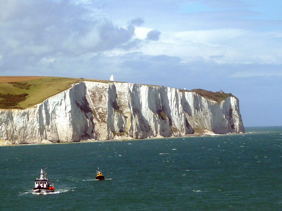
While most people associate white cliffs with the coast of England, geologists and Western historians point to the White Cliffs of the Green River in Wyoming as a stunning American equivalent. These massive limestone and siltstone formations rise sharply from the riverbanks, glowing with a brilliant white and pale yellow hue. Experts explain that these cliffs were formed from the sediments of ancient Lake Gosiute, which covered the region millions of years ago. The cliffs served as a major landmark for pioneers on the Oregon Trail, who used the towering white walls as a beacon across the high desert plains.
Photography experts suggest that the best time to view these cliffs is during the “golden hour,” when the setting sun reflects off the pale rock, creating an ethereal glow. The contrast between the white stone and the sagebrush-covered hills provides a stark visual that is unlike anything else in the Rocky Mountain region. Many travelers discover these cliffs while visiting the town of Green River, finding that the unexpected scale of the formations rivals more famous national monuments. The vertical faces are often dotted with the nests of raptors, who take advantage of the high, inaccessible ledges for safety.
Historical consultants emphasize that the cliffs have been a site of human significance for thousands of years, with Indigenous petroglyphs found in sheltered alcoves along the base. The feeling of standing at the foot of these ancient, white walls is one of being a small part of a much larger story. For the modern traveler, the cliffs offer a chance to see a part of the American West that still feels relatively undiscovered. The memory of those towering, sun-bleached walls against a deep blue Wyoming sky is a highlight of any cross-country journey.
Dead Horse Point In Utah

Landscape architects and desert photographers often cite Dead Horse Point as the most visually compelling overlook in the entire state of Utah. This cliff sits two thousand feet above a massive gooseneck in the Colorado River, providing a view that seems to stretch all the way to the edge of the world. Experts explain that the point is a narrow neck of land surrounded by sheer cliffs on all sides, a geographic feature that was once used by cowboys to corral wild horses. The vertical walls are composed of Kayenta and Wingate sandstone, which glow with a deep, saturated red in the afternoon light.
Geology professors point out that the view from Dead Horse Point reveals the complex layers of the Canyonlands region, with different mesas and buttes appearing like a giant staircase leading down to the river. The vastness of the vista is so great that it can be difficult for the human eye to process the scale, making the experience feel almost surreal. For many women, the stillness of the high desert and the absolute silence at the rim create a space for deep contemplation. The sense of being elevated above the chaotic world below is a powerful psychological draw.
Travel guides recommend visiting the point during a full moon, as the silver light transforms the red cliffs into a ghostly, monochromatic landscape. The shadows in the deep canyons below become even more mysterious, and the stars appear close enough to touch in the high-altitude air. The physical sensation of the vast, open space and the knowledge of the sheer drop just a few feet away creates an adrenaline-fueled clarity. It is a location that demands full attention, ensuring that the visual and emotional impact of the visit is never forgotten.
Zion Canyon’s Angels Landing
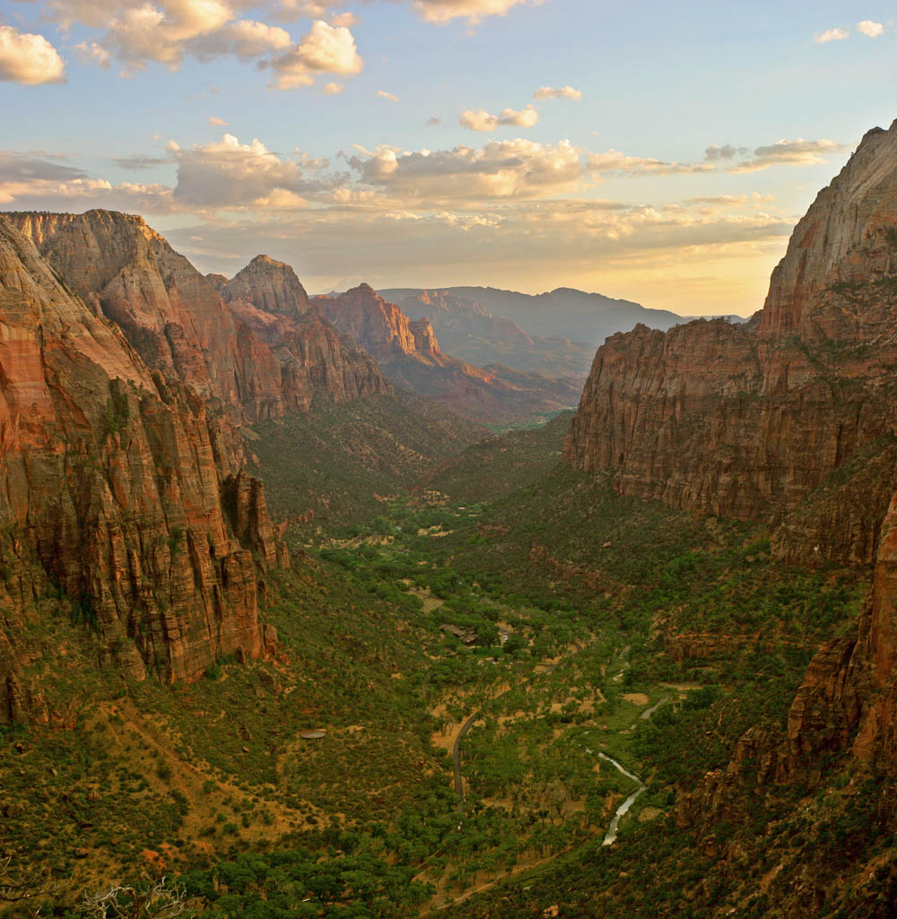
Wilderness rangers and hiking experts consider Angels Landing in Zion National Park to be the most exhilarating and terrifying cliff experience in the United States. The trail ends at a narrow ridge with thousand-foot drops on both sides, leading to a summit that offers an unobstructed view of the entire Zion Canyon. Experts explain that the ridge is so narrow in sections that the National Park Service has installed heavy iron chains to help hikers maintain their balance. This vertical journey is not for the faint of heart, as the psychological pressure of the surrounding heights is constant.
Geologists describe the rock at Angels Landing as Navajo sandstone, which is known for its durability and its ability to form steep, vertical walls. The way the Virgin River has carved through this stone to create the deep, narrow canyon is a classic example of fluvial erosion. For the traveler, the view from the top is a reward for a significant mental and physical challenge, providing a bird’s-eye perspective of the lush canyon floor and the surrounding red peaks. The sense of accomplishment that comes from standing on that narrow prow of rock is a memory that many women carry as a badge of courage.
Safety consultants emphasize the importance of the permit system, which was implemented to manage the crowds on the narrowest sections of the trail. This regulation ensures that those who undertake the climb can do so with a measure of space and quiet, allowing the true impact of the height to sink in. The physical memory of gripping the cold iron chains while looking down into the green valley below is a sensory experience that stays vivid for years. It is a place where the boundary between the earth and the sky feels remarkably thin, leaving an indelible mark on the soul.